
1980 Map of Westport
USGS Topo · Published 1990About this map
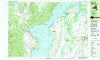
Lake Champlain serves as the central divide in this 1980 survey, where the Adirondack Park foothills of New York meet the fertile lowlands of Vermont. On the western shore, the village of Westport is a focal point of activity, featuring the Westport Sch, a marina, and the tracks of the Delaware and Hudson railroad running parallel to the coast. The topography here is defined by significant elevations like Hoisington Mtn and The Pinnacle, contrasting sharply with the flatter terrain around Vergennes and Ferrisburg on the eastern side.
Find a feature on this map
114 named features on this map. Tap any name to fly to it.
Don’t see what you’re looking for? This feature index may not catch every label — zoom into the map to look around manually.
Map Details
Editions of this 1980 Westport Map
3 editions found

Other maps of this area

1894 · Elizabethtown
USGS Topo · 1:62,500

1894 · Port Henry
USGS Topo · 1:62,500

1895 · Willsboro
USGS Topo · 1:62,500

1895 · Elizabethtown
USGS Topo · 1:62,500

1895 · Ausable
USGS Topo · 1:62,500

1898 · Port Henry
USGS Topo · 1:62,500

1901 · Elizabethtown
USGS Topo · 1:62,500

1903 · Ausable
USGS Topo · 1:62,500

1903 · Middlebury
USGS Topo · 1:62,500

1905 · Middlebury
USGS Topo · 1:62,500