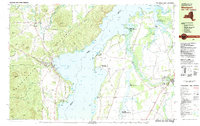
1980 Map of Westport
USGS Topo · Published 1981About this map
Lake Champlain serves as the central focal point of this 1980 survey, dividing the Adirondack foothills of New York from the lowlands of Vermont. On the western shore, the village of Westport is a primary hub of activity, featuring its Golf Course, Westport Airport, and the historic Camp Dudley at the edge of North West Bay. The Delaware and Hudson railroad tracks run parallel to the coast, passing through the hamlet of Wadhams and navigating the steep terrain beneath Split Rock Mountain.
Find a feature on this map
103 named features on this map. Tap any name to fly to it.
Don’t see what you’re looking for? This feature index may not catch every label — zoom into the map to look around manually.
Map Details
Editions of this 1980 Westport Map
3 editions found
Other maps of this area

1894 · Elizabethtown
USGS Topo · 1:62,500

1894 · Port Henry
USGS Topo · 1:62,500

1895 · Willsboro
USGS Topo · 1:62,500

1895 · Elizabethtown
USGS Topo · 1:62,500

1895 · Ausable
USGS Topo · 1:62,500

1898 · Port Henry
USGS Topo · 1:62,500

1901 · Elizabethtown
USGS Topo · 1:62,500

1903 · Ausable
USGS Topo · 1:62,500

1903 · Middlebury
USGS Topo · 1:62,500

1905 · Middlebury
USGS Topo · 1:62,500