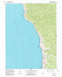
1966 Map of Westport
USGS Topo · Published 1994About this map
The coastal settlement of Westport anchors this mid-century view of the Mendocino shoreline, where the land rises sharply from the Pacific Ocean into a series of ridges. This 1966 topographic survey, updated through the early 1990s, captures the small coastal outposts of Rockport, Hardy, and DeHaven as they appeared before modern shifts. The landscape is defined by the steep drainage basins of Cottaneva Creek and Juan Creek, which carve through timbered terrain marked by Cottaneva Ridge and Alviso Ridge.
Find a feature on this map
45 named features on this map. Tap any name to fly to it.
Don’t see what you’re looking for? This feature index may not catch every label — zoom into the map to look around manually.
Map Details
Editions of this 1966 Westport Map
3 editions found
Other maps of this area

1920 · Cummings
USGS Topo · 1:62,500

1921 · Westport
USGS Topo · 1:62,500

1921 · Branscomb
USGS Topo · 1:62,500

1950 · Piercy
USGS Topo · 1:62,500

1950 · Cape Vizcaino
USGS Topo · 1:62,500

1951 · Cape Vizcaino
USGS Topo · 1:62,500

1951 · Branscomb
USGS Topo · 1:62,500

1952 · Leggett
USGS Topo · 1:62,500

1957 · Ukiah
USGS Topo · 1:250,000

1960 · Ukiah
USGS Topo · 1:250,000