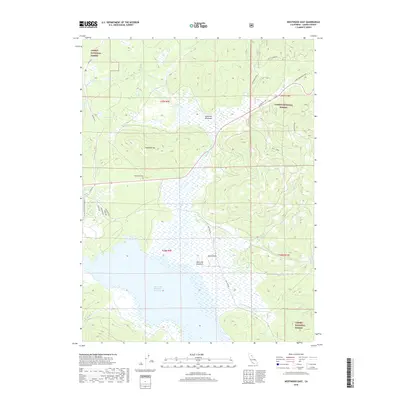
2018 Map of Westwood East
USGS Topo · Published 2018About this map
Mountain Meadows Reservoir dominates the southern landscape of this 2018 survey, reflecting a complex water management system within the Lassen National Forest. The map documents a transition from the marshy expanse of Mountain Meadows to the higher elevations of Goodrich Mtn and Hamilton Mtn. Traces of the area's local history are visible through landmarks such as the Westwood Cem and the naming of Old Town Rd, which suggests the evolution of earlier settlements in this part of Lassen County. The drainage patterns are clearly defined by Goodrich Cr and Duffy Creek, which feed into the central basin. North of the reservoir, the terrain opens into high-altitude clearings like McKenzie Meadows and isolated peaks including Round Mtn. Road networks like the Coppervale Loop and Co Hwy A21 provide the primary access through this timbered and lacustrine environment.
Find a feature on this map
32 named features on this map. Tap any name to fly to it.
Don’t see what you’re looking for? This feature index may not catch every label — zoom into the map to look around manually.
Map Details
Editions of this 2018 Westwood East Map
This is the sole edition of this map. No revisions or reprints were ever made.
Other maps of this area

1886 · Honey Lake
USGS Topo · 1:250,000

1886 · Lassen Peak
USGS Topo · 1:250,000

1891 · Honey Lake
USGS Topo · 1:250,000

1892 · Lassen Peak
USGS Topo · 1:250,000

1893 · Honey Lake
USGS Topo · 1:250,000

1894 · Lassen Peak
USGS Topo · 1:250,000

1950 · Greenville
USGS Topo · 1:62,500

1955 · Westwood
USGS Topo · 1:62,500

1955 · Almanor
USGS Topo · 1:62,500

1955 · Westwood
USGS Topo · 1:250,000