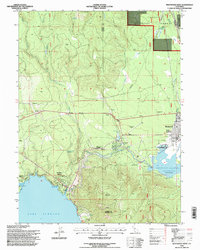
1995 Map of Westwood West
USGS Topo · Published 1998About this map
Westwood and its surroundings in the late twentieth century are defined by the meeting of the High Sierra and the Great Basin, dominated by timberlands and hydroelectric infrastructure. The community features essential civic landmarks such as Fletcher Walker High Sch and a local Grave, while the Westwood Airport and a Westwood Dump sit on the town's western periphery. Transport and utility routes are evident along Telephone Road and the various service tracks traversing the Lassen National Forest.
Find a feature on this map
41 named features on this map. Tap any name to fly to it.
Don’t see what you’re looking for? This feature index may not catch every label — zoom into the map to look around manually.
Map Details
Editions of this 1995 Westwood West Map
This is the sole edition of this map. No revisions or reprints were ever made.
Other maps of this area

1886 · Honey Lake
USGS Topo · 1:250,000

1886 · Lassen Peak
USGS Topo · 1:250,000

1891 · Honey Lake
USGS Topo · 1:250,000

1892 · Lassen Peak
USGS Topo · 1:250,000

1893 · Honey Lake
USGS Topo · 1:250,000

1894 · Lassen Peak
USGS Topo · 1:250,000

1950 · Greenville
USGS Topo · 1:62,500

1955 · Westwood
USGS Topo · 1:62,500

1955 · Almanor
USGS Topo · 1:62,500

1955 · Westwood
USGS Topo · 1:250,000