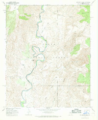
1967 Map of Wet Bottom Mesa
USGS Topo · Published 1968About this map
The Verde River carves a winding path through this central Arizona landscape, forming a natural boundary between Yavapai and Gila Counties. Within the protected reaches of the Tonto National Forest and the Mazatzal Wilderness, the terrain is defined by dramatic geological features such as Mule Shoe Bend and the flat-topped Wet Bottom Mesa. This 1967 field-checked survey highlights a transition from water-carved canyons to high mesas like Petes Cabin Mesa and the Limestone Hills. Human presence is minimal, marked primarily by a network of trails and a remote Landing Strip near Red Creek. The map documents essential water sources for cattle and wildlife in this arid environment, including Peach Tank, Table Mtn Tank, and various unnamed springs, reflecting the region's history of ranching and early backcountry aviation.
Find a feature on this map
38 named features on this map. Tap any name to fly to it.
Don’t see what you’re looking for? This feature index may not catch every label — zoom into the map to look around manually.
Map Details
Editions of this 1967 Wet Bottom Mesa Map
This is the sole edition of this map. No revisions or reprints were ever made.
Other maps of this area

1887 · Verde
USGS Topo · 1:250,000

1892 · Verde
USGS Topo · 1:250,000

1929 · Turret Peak
USGS Topo · 1:125,000

1933 · Turret Peak
USGS Topo · 1:125,000

1954 · Holbrook
USGS Topo · 1:250,000

1957 · Holbrook
USGS Topo · 1:250,000

1958 · Holbrook
USGS Topo · 1:250,000

1960 · Holbrook
USGS Topo · 1:250,000
1967 · Chalk Mountain
USGS Topo · 1:24,000
1967 · Tule Mesa
USGS Topo · 1:24,000