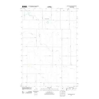
2012 Map of Wetonka South
USGS Topo · Published 2012About this map
Snake Cr meanders southward through this rural section of McPherson County, defining the drainage patterns of a landscape marked by sectional road grids and scattered water bodies. The presence of Long Lake Colony in the northern portion of the map suggests a communal agricultural settlement, a characteristic element of the local cultural geography. To the northwest, Crompton Lake sits near the edge of the survey area, while the rural heritage of the region is anchored by two distinct burial grounds: Wetonka Cem in the northeast and Pembrook Cem further south. The map's grid is composed of numbered roads like 122nd St and 367th Ave, illustrating the highly organized survey system that governs this prairie environment.
Find a feature on this map
22 named features on this map. Tap any name to fly to it.
Don’t see what you’re looking for? This feature index may not catch every label — zoom into the map to look around manually.
Map Details
Editions of this 2012 Wetonka South Map
This is the sole edition of this map. No revisions or reprints were ever made.
Other maps of this area

1899 · Ellendale
USGS Topo · 1:125,000

1899 · Northville
USGS Topo · 1:125,000

1954 · Aberdeen
USGS Topo · 1:250,000

1956 · Aberdeen
USGS Topo · 1:250,000

1970 · Lake Parmley
USGS Topo · 1:24,000

1970 · Wetonka South
USGS Topo · 1:24,000

1970 · Mina NW
USGS Topo · 1:24,000

1970 · Leola
USGS Topo · 1:24,000
1970 · Richmond SW
USGS Topo · 1:24,000
1970 · Mina
USGS Topo · 1:24,000