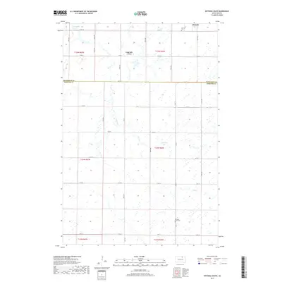
2017 Map of Wetonka South
USGS Topo · Published 2017About this map
Wetonka lies at the northern edge of this high plains landscape, situated near the boundary where McPherson Co and Edmunds Co meet. The geography is defined by a dense network of prairie potholes and wetlands, with Snake Creek winding southward through the center of the survey. Cultural and communal landmarks include the Long Lake Colony and the southern Pembrook Colony Cem, reflecting the region's specific patterns of settlement and agricultural heritage. Water features like Crompton Lake and several smaller unnamed basins suggest a landscape heavily influenced by seasonal moisture and drainage. The rectilinear road grid, marked by routes such as Co Hwy 18 and 371st Ave, provides the primary structure for the rural homesteads scattered throughout these townships.
Find a feature on this map
30 named features on this map. Tap any name to fly to it.
Don’t see what you’re looking for? This feature index may not catch every label — zoom into the map to look around manually.
Map Details
Editions of this 2017 Wetonka South Map
This is the sole edition of this map. No revisions or reprints were ever made.
Other maps of this area

1899 · Ellendale
USGS Topo · 1:125,000

1899 · Northville
USGS Topo · 1:125,000

1954 · Aberdeen
USGS Topo · 1:250,000

1956 · Aberdeen
USGS Topo · 1:250,000

1970 · Lake Parmley
USGS Topo · 1:24,000

1970 · Wetonka South
USGS Topo · 1:24,000

1970 · Mina NW
USGS Topo · 1:24,000

1970 · Leola
USGS Topo · 1:24,000
1970 · Richmond SW
USGS Topo · 1:24,000
1970 · Mina
USGS Topo · 1:24,000