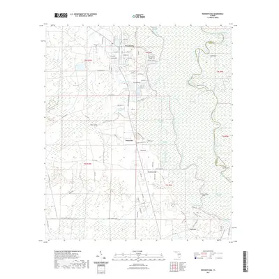
2021 Map of Wewahitchka
USGS Topo · Published 2021About this map
The confluence of the Apalachicola River and the Chipola River creates a labyrinthine wetland landscape dominated by sloughs, reaches, and cutoffs. The community of Wewahitchka sits at the northern edge of this aquatic network, serving as a gateway to the intricate waterways of Magnolia Slough and Whites River. This modern survey reveals a geography shaped by water, where small settlements like Honeyville and Gaskins Still occupy the higher ground between the river systems. Local history is anchored by several rural burial grounds, including Williamsburg Cem, Roberts Cem, and Robertson Cem, which provide critical points of reference for genealogists. The southern portion of the map transitions toward Dalkeith, following the bend of the Chipola River through a landscape punctuated by landmarks such as Pockey Lake and the Sheep Islands, illustrating the persistent role of these river corridors in defining local transport and land use.
Find a feature on this map
96 named features on this map. Tap any name to fly to it.
Don’t see what you’re looking for? This feature index may not catch every label — zoom into the map to look around manually.
Map Details
Editions of this 2021 Wewahitchka Map
This is the sole edition of this map. No revisions or reprints were ever made.
Other maps of this area

1943 · Overstreet
USGS Topo · 1:31,680

1944 · White City
USGS Topo · 1:24,000

1944 · Forbes Island
USGS Topo · 1:24,000

1945 · Dead Lake
USGS Topo · 1:31,680

1945 · Forbes Island
USGS Topo · 1:31,680

1945 · Kennedy Creek
USGS Topo · 1:31,680

1945 · White City
USGS Topo · 1:31,680

1945 · Orange
USGS Topo · 1:31,680

1945 · Wewahitchka
USGS Topo · 1:31,680

1945 · Wetappo Creek
USGS Topo · 1:31,680