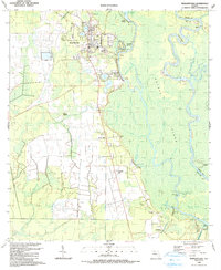
1990 Map of Wewahitchka
USGS Topo · Published 1990About this map
The Apalachicola River and the Chipola River dominate this Gulf County landscape, where the confluence at the Chipola Cutoff creates a complex network of waterways including Dead Lakes and Magnolia Slough. Wewahitchka serves as the primary hub of activity, featuring civic landmarks such as the High Sch and several religious centers like St Lawrence Ch. The map reveals the intricate water management required for the region, noted by the St Joe Paper Co Fresh Water Canal and various levees protecting the low-lying terrain.
Find a feature on this map
54 named features on this map. Tap any name to fly to it.
Don’t see what you’re looking for? This feature index may not catch every label — zoom into the map to look around manually.
Map Details
Editions of this 1990 Wewahitchka Map
This is the sole edition of this map. No revisions or reprints were ever made.
Other maps of this area

1943 · Overstreet
USGS Topo · 1:31,680

1944 · White City
USGS Topo · 1:24,000

1944 · Forbes Island
USGS Topo · 1:24,000

1945 · Dead Lake
USGS Topo · 1:31,680

1945 · Forbes Island
USGS Topo · 1:31,680

1945 · Kennedy Creek
USGS Topo · 1:31,680

1945 · White City
USGS Topo · 1:31,680

1945 · Orange
USGS Topo · 1:31,680

1945 · Wewahitchka
USGS Topo · 1:31,680

1945 · Wetappo Creek
USGS Topo · 1:31,680