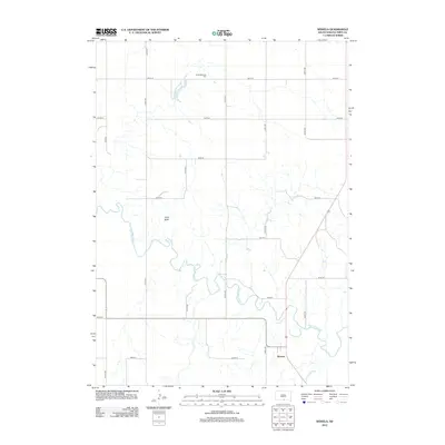
2012 Map of Wewela
USGS Topo · Published 2012About this map
The Keya Paha River meanders across the southern portion of this landscape, defining the topography of the Ideal Segment in Tripp County. The small community of Wewela sits just north of the river, serving as a focal point in a region characterized by a disciplined grid of rural section roads like 319th Ave and 301st St. Significant landmarks for family history research include the Congregational Cem in the northern reaches and the distinct elevation of Turtle Butte situated between the river and the northern plains. Water resources are central to the area's layout, from the flow of Timber Cr to the quiet waters of Rahn Lake. This survey illustrates the persistent agricultural and ranching structure of South Dakota's southern borderlands in the early 21st century.
Find a feature on this map
21 named features on this map. Tap any name to fly to it.
Don’t see what you’re looking for? This feature index may not catch every label — zoom into the map to look around manually.
Map Details
Editions of this 2012 Wewela Map
This is the sole edition of this map. No revisions or reprints were ever made.
Other maps of this area

1955 · Mitchell
USGS Topo · 1:250,000

1955 · O'Neill
USGS Topo · 1:250,000

1959 · O'Neill
USGS Topo · 1:250,000

1959 · Mitchell
USGS Topo · 1:250,000

1964 · Dallas SW
USGS Topo · 1:24,000
1964 · Meadville NW
USGS Topo · 1:24,000
1964 · Springview NW
USGS Topo · 1:24,000

1964 · Dallas NW
USGS Topo · 1:24,000
1964 · Meadville NE
USGS Topo · 1:24,000

1969 · O'Neill
USGS Topo · 1:250,000