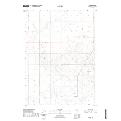
2017 Map of Wewela
USGS Topo · Published 2017About this map
The Keya Paha River winds through this section of Tripp County, shaping the local topography near the small settlement of Wewela. This southern South Dakota landscape is defined by its transition from prairie uplands to the river valley, most notably at Turtle Butte. Local history is anchored by the presence of the Congregational Cem and Hope Lutheran Cem, which reflect the community's early social and religious foundations. A strictly gridded road network, including Musilek Ave and several numeric routes like 303rd St, overlays the natural drainage of Timber Cr and Rahn Lake. The map demonstrates the persistence of rural township structures like t96n r76w and t95n r75w in an area primarily dedicated to agriculture and grazing.
Find a feature on this map
30 named features on this map. Tap any name to fly to it.
Don’t see what you’re looking for? This feature index may not catch every label — zoom into the map to look around manually.
Map Details
Editions of this 2017 Wewela Map
This is the sole edition of this map. No revisions or reprints were ever made.
Other maps of this area

1955 · Mitchell
USGS Topo · 1:250,000

1955 · O'Neill
USGS Topo · 1:250,000

1959 · O'Neill
USGS Topo · 1:250,000

1959 · Mitchell
USGS Topo · 1:250,000

1964 · Dallas SW
USGS Topo · 1:24,000
1964 · Meadville NW
USGS Topo · 1:24,000
1964 · Springview NW
USGS Topo · 1:24,000

1964 · Dallas NW
USGS Topo · 1:24,000
1964 · Meadville NE
USGS Topo · 1:24,000

1969 · O'Neill
USGS Topo · 1:250,000