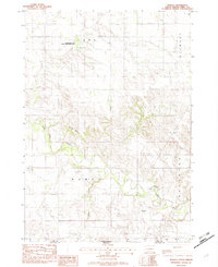
1982 Map of Wewela
USGS Topo · Published 1982About this map
Wewela sits near the border of South Dakota and Nebraska, overlooking the winding path of the Keya Paha River. This early 1980s provisional survey shows the rural landscape of Tripp County, defined by its water resources and conservation areas like the Rahn Dam State Game Production Area. The topography is marked by significant features such as Turtle Butte and the drainage of Timber Creek, which shape the agricultural and grazing land in the region. Local community life is rooted in landmarks like St Pauls Ch, Congregational Cem, and another smaller Cem located near the township line. The map serves as a record of the high plains before further modernization, documenting the specific locations of Rahn Lake and the small residential footprint of Wewela at the turn of the decade.
Find a feature on this map
13 named features on this map. Tap any name to fly to it.
Don’t see what you’re looking for? This feature index may not catch every label — zoom into the map to look around manually.
Map Details
Editions of this 1982 Wewela Map
This is the sole edition of this map. No revisions or reprints were ever made.
Other maps of this area

1955 · Mitchell
USGS Topo · 1:250,000

1955 · O'Neill
USGS Topo · 1:250,000

1959 · O'Neill
USGS Topo · 1:250,000

1959 · Mitchell
USGS Topo · 1:250,000

1964 · Dallas SW
USGS Topo · 1:24,000
1964 · Meadville NW
USGS Topo · 1:24,000
1964 · Springview NW
USGS Topo · 1:24,000

1964 · Dallas NW
USGS Topo · 1:24,000
1964 · Meadville NE
USGS Topo · 1:24,000

1969 · O'Neill
USGS Topo · 1:250,000