
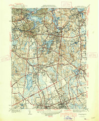
1941 Map of Weymouth
USGS Topo · Published 1949About this map
Industrial and maritime activity define the South Shore landscape on this sheet, where the Fore River Shipyard stands as a massive landmark along the Fore River near Quincy. Extensive U S Naval Reservation lands dominate the terrain between the Back River and the Hingham border, illustrating the significant military presence in the area during the mid-century. Further inland, the map captures a cluster of settlements including East Weymouth, South Weymouth, and Braintree, connected by the New York New Haven and Hartford RR.
Find a feature on this map
132 named features on this map. Tap any name to fly to it.
Don’t see what you’re looking for? This feature index may not catch every label — zoom into the map to look around manually.
Map Details
Editions of this 1941 Weymouth Map
3 editions found
Other maps of this area

1885 · Abington
USGS Topo · 1:62,500

1886 · Dedham
USGS Topo · 1:62,500

1888 · Abington
USGS Topo · 1:62,500

1892 · Boston Bay
USGS Topo · 1:62,500

1893 · Abington
USGS Topo · 1:62,500

1893 · Boston
USGS Topo · 1:62,500

1894 · Dedham
USGS Topo · 1:62,500

1903 · Boston
USGS Topo · 1:62,500

1903 · Boston Bay
USGS Topo · 1:62,500

1919 · Dedham
USGS Topo · 1:62,500