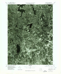
1977 Map of Weymouth
USGS Topo · Published 1980About this map
Weymouth and its surrounding South Shore communities are captured in this 1977 orthophoto, which uses aerial photography to provide a literal view of the landscape during a period of significant suburban density. The intricate network of coastal inlets is defined by the Weymouth Fore River and the Weymouth Back River, highlighting the area's deep connection to the water. Unlike traditional topographic maps, this imagery reveals the exact footprint of residential developments and industrial zones stretching from Quincy down toward Rockland.
Find a feature on this map
13 named features on this map. Tap any name to fly to it.
Don’t see what you’re looking for? This feature index may not catch every label — zoom into the map to look around manually.
Map Details
Editions of this 1977 Weymouth Map
This is the sole edition of this map. No revisions or reprints were ever made.
Other maps of this area

1885 · Abington
USGS Topo · 1:62,500

1886 · Dedham
USGS Topo · 1:62,500

1888 · Abington
USGS Topo · 1:62,500

1892 · Boston Bay
USGS Topo · 1:62,500

1893 · Abington
USGS Topo · 1:62,500

1893 · Boston
USGS Topo · 1:62,500

1894 · Dedham
USGS Topo · 1:62,500

1903 · Boston
USGS Topo · 1:62,500

1903 · Boston Bay
USGS Topo · 1:62,500

1919 · Dedham
USGS Topo · 1:62,500