
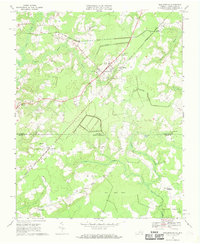
1967 Map of Whaleyville
USGS Topo · Published 1981About this map
The town of Whaleyville serves as the focal point for this survey of the Tidewater borderlands, where the coastal plain of Virginia meets North Carolina. The landscape is defined by vast wetland systems including Jones Swamp and Spivey Swamp, alongside unique peatland features like the Black Mingle Pocosin and Hall Pocosin. The area's agricultural and timber history is evident in the network of small rural settlements such as Somerton, Drum Hill, and Hazelton.
Find a feature on this map
35 named features on this map. Tap any name to fly to it.
Don’t see what you’re looking for? This feature index may not catch every label — zoom into the map to look around manually.
Map Details
Editions of this 1967 Whaleyville Map
Historical Maps of Willeyton Through Time
85 maps found

1907 Norfolk
Virginia

1916 Back Bay
Virginia

1918 Cape Henry
Virginia

1919 Cape Henry
Virginia

1919 Suffolk
Virginia

1931 Rural Retreat
Virginia

1935 Charlottesville And Vicinity
Virginia

1940 Lake Drummond
Virginia

1943 Back Bay
Virginia

1944 Hampton
Virginia

1944 Norfolk South
Virginia

1945 Lake Drummond
Virginia

1948 Kempsville
Virginia

1948 Norfolk North
Virginia

1948 Norfolk South
Virginia

1948 Ocean View
Virginia

1948 Princess Anne
Virginia

1948 Virginia Beach
Virginia

1952 Bowers Hill
Virginia

1952 Cape Henry
Virginia

1953 North Bay
Virginia

1954 Buckhorn
Virginia

1954 Corapeake
Virginia

1954 Creeds
Virginia

1954 Deep Creek
Virginia

1954 Fentress
Virginia

1954 Knotts Island
Virginia

1954 Lake Drummond
Virginia

1954 Lake Drummond NW
Virginia

1954 Lake Drummond SE
Virginia

1954 Ocean View
Virginia

1954 Pleasant Ridge
Virginia

1954 Suffolk
Virginia

1954 Suffolk
Virginia

1955 Bowers Hill
Virginia

1955 Cape Henry
Virginia

1955 Hampton
Virginia

1955 Kempsville
Virginia

1955 Norfolk North
Virginia

1955 Norfolk South
Virginia

1955 Princess Anne
Virginia

1955 Virginia Beach
Virginia

1960 Charlottesville And Vicinity
Virginia

1964 Cape Henry
Virginia

1964 Little Creek
Virginia

1965 Bowers Hill
Virginia

1965 Hampton
Virginia

1965 Kempsville
Virginia

1965 Norfolk North
Virginia

1965 Norfolk South
Virginia

1965 Princess Anne
Virginia

1965 Virginia Beach
Virginia
1967 Whaleyville
Virginia

1973 Hampton
Virginia

1977 Corapeake
Virginia

1977 Creeds
Virginia

1977 Deep Creek
Virginia

1977 Lake Drummond
Virginia

1977 Lake Drummond NW
Virginia

1977 Lake Drummond SE
Virginia

1977 Suffolk
Virginia

1994 Bowers Hill
Virginia

1994 Kempsville
Virginia

1994 Norfolk South
Virginia

1997 Suffolk
Virginia

2022 Bowers Hill
Virginia

2022 Buckhorn
Virginia

2022 Cape Henry
Virginia

2022 Creeds
Virginia

2022 Deep Creek
Virginia

2022 Fentress
Virginia

2022 Hampton
Virginia

2022 Lake Drummond
Virginia

2022 Lake Drummond NW
Virginia

2022 Lake Drummond SE
Virginia

2022 Little Creek
Virginia

2022 Norfolk North
Virginia

2022 Norfolk South
Virginia

2022 North Bay
Virginia

2022 Pleasant Ridge
Virginia

2022 Princess Anne
Virginia

2022 Suffolk
Virginia

2022 Virginia Beach
Virginia

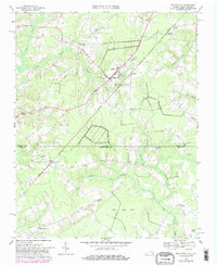
2022 Whaleyville
Virginia

2023 Kempsville
Virginia