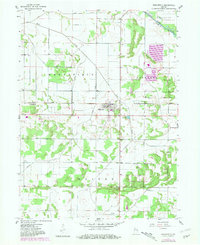
1957 Map of Wheatfield
USGS Topo · Published 1980About this map
Wheatfield serves as the central hub of this northern Indiana landscape, where the flat terrain of Kankakee and Walker townships is defined by an extensive network of drainage infrastructure. Originally surveyed in 1957 with revisions added by 1980, the map illustrates the critical role of water management in the region, featuring numerous named waterways such as James Ditch, Delehanty Ditch, and Wolf Creek. These man-made and natural channels support the agricultural productivity of the black-soil prairie land south of the Kankakee River.
Find a feature on this map
23 named features on this map. Tap any name to fly to it.
Don’t see what you’re looking for? This feature index may not catch every label — zoom into the map to look around manually.
Map Details
Editions of this 1957 Wheatfield Map
2 editions found
Other maps of this area

1953 · Hebron
USGS Topo · 1:24,000

1953 · Kouts
USGS Topo · 1:24,000

1953 · Chicago
USGS Topo · 1:250,000

1957 · Chicago
USGS Topo · 1:250,000

1957 · Wheatfield
USGS Topo · 1:24,000

1957 · DeMotte
USGS Topo · 1:24,000

1958 · La Crosse
USGS Topo · 1:24,000

1959 · San Pierre
USGS Topo · 1:24,000

1962 · Medaryville
USGS Topo · 1:24,000

1962 · Gifford
USGS Topo · 1:24,000