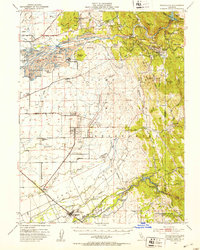
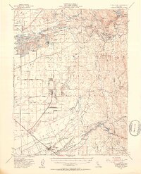
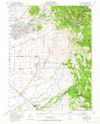
1949 Map of Wheatland
USGS Topo · Published 1953About this map
The Yuba River and Bear River define this landscape at the edge of the Sierra Nevada foothills, where the massive Camp Beale Military Reservation dominates the central and southern terrain. In this post-war era, the map captures the extensive industrial footprint of gold dredging near Hammonton and Marigold, where large fields of Tailings follow the river's course. These man-made landforms stand in contrast to the historical remnants of the Gold Rush, including the sites of Timbuctoo and Smartville near the Yuba River.
Find a feature on this map
85 named features on this map. Tap any name to fly to it.
Don’t see what you’re looking for? This feature index may not catch every label — zoom into the map to look around manually.
Map Details
Editions of this 1949 Wheatland Map
3 editions found
Other maps of this area

1888 · Marysville
USGS Topo · 1:125,000

1888 · Smartsville
USGS Topo · 1:125,000

1891 · Sacramento
USGS Topo · 1:125,000

1891 · Marysville
USGS Topo · 1:125,000

1891 · Smartsville
USGS Topo · 1:125,000

1892 · Sacramento
USGS Topo · 1:125,000

1892 · Smartsville
USGS Topo · 1:125,000

1893 · Sacramento
USGS Topo · 1:125,000

1894 · Smartsville
USGS Topo · 1:125,000

1894 · Marysville
USGS Topo · 1:125,000