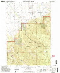
2000 Map of Wheeler Mountain
USGS Topo · Published 2005About this map
Gallatin National Forest dominates the southern reaches of this landscape, where the high elevations of Wheeler Mountain and the open expanse of Tom Lay Prairie define the mountain terrain. Water management is a primary theme of the early 2000s era shown here, evidenced by the complex network of the West Gallatin Canal, the Association Ditch, and several other unnamed irrigation lines feeding the valley floors.
Find a feature on this map
31 named features on this map. Tap any name to fly to it.
Don’t see what you’re looking for? This feature index may not catch every label — zoom into the map to look around manually.
Map Details
Editions of this 2000 Wheeler Mountain Map
This is the sole edition of this map. No revisions or reprints were ever made.
Other maps of this area

1888 · Three Forks
USGS Topo · 1:250,000

1891 · Livingston
USGS Topo · 1:250,000

1893 · Livingston
USGS Topo · 1:250,000

1894 · Three Forks
USGS Topo · 1:250,000

1895 · Three Forks
USGS Topo · 1:250,000

1947 · Bozeman
USGS Topo · 1:250,000

1948 · Bozeman
USGS Topo · 1:250,000

1951 · Bozeman Pass
USGS Topo · 1:62,500

1953 · Bozeman
USGS Topo · 1:62,500

1955 · Bozeman
USGS Topo · 1:250,000