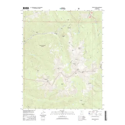
2017 Map of Wheeler Peak
USGS Topo · Published 2017About this map
Wheeler Peak stands as the high point of this high-altitude landscape within the Carson National Forest, anchoring a terrain defined by the alpine basins and glacial lakes of the Sangre de Cristo Mountains. The settlement at Taos Ski Valley and the nearby site of Twining reflect the human footprint in these mountains, where recreation and earlier mining efforts have historically converged. A network of headwaters, including the Rio Hondo and Rio Lucero, drains the steep slopes surrounding peaks like Bull-of-the-Woods Mtn and Lobo Peak. The map provides detailed placement for prominent water bodies such as Williams Lake, Blue Lake, and Lost Lake, illustrating the complex drainage patterns that feed into the Rio Pueblo de Taos. This survey captures the topographical intricacies of the Taos Co highlands, showing the intersections of designated forest land and tribal boundaries.
Find a feature on this map
57 named features on this map. Tap any name to fly to it.
Don’t see what you’re looking for? This feature index may not catch every label — zoom into the map to look around manually.
Map Details
Editions of this 2017 Wheeler Peak Map
This is the sole edition of this map. No revisions or reprints were ever made.
Other maps of this area

1954 · Raton
USGS Topo · 1:250,000

1958 · Raton
USGS Topo · 1:250,000

1963 · Wheeler Peak
USGS Topo · 1:24,000

1963 · Eagle Nest
USGS Topo · 1:24,000

1963 · Arroyo Seco
USGS Topo · 1:24,000

1963 · Red River Pass
USGS Topo · 1:24,000

1963 · Questa
USGS Topo · 1:24,000

1963 · Red River
USGS Topo · 1:24,000

1964 · Taos
USGS Topo · 1:24,000

1965 · Palo Flechado Pass
USGS Topo · 1:24,000