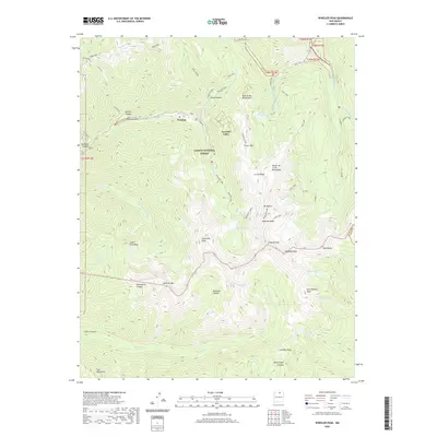
2020 Map of Wheeler Peak
USGS Topo · Published 2020About this map
The high-altitude village of Taos Ski Valley sits at the base of some of New Mexico's most prominent terrain, anchored by the towering Wheeler Peak and its neighboring Wheeler Summit. Located within the Carson National Forest, this mountainous landscape is defined by the drainage of the Rio Hondo and the nearby settlement of Twining. The map documents a complex alpine hydrology where numerous glacial lakes, including Williams Lake, Blue Lake, and Horseshoe Lake, dot the basins below jagged summits like Old Mike Peak and Lew Wallace Peak.
Find a feature on this map
58 named features on this map. Tap any name to fly to it.
Don’t see what you’re looking for? This feature index may not catch every label — zoom into the map to look around manually.
Map Details
Editions of this 2020 Wheeler Peak Map
This is the sole edition of this map. No revisions or reprints were ever made.
Other maps of this area

1954 · Raton
USGS Topo · 1:250,000

1958 · Raton
USGS Topo · 1:250,000

1963 · Wheeler Peak
USGS Topo · 1:24,000

1963 · Eagle Nest
USGS Topo · 1:24,000

1963 · Arroyo Seco
USGS Topo · 1:24,000

1963 · Red River Pass
USGS Topo · 1:24,000

1963 · Questa
USGS Topo · 1:24,000

1963 · Red River
USGS Topo · 1:24,000

1964 · Taos
USGS Topo · 1:24,000

1965 · Palo Flechado Pass
USGS Topo · 1:24,000