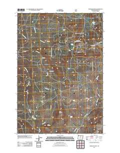
2011 Map of Wheeler Point
USGS Topo · Published 2011About this map
Winlock sits as the primary settlement area in this high-desert landscape of Wheeler County, situated along Winlock Ln and J Point Rd. The terrain is defined by a series of open meadows and high points, including the prominent Wheeler Point and Frizzel Mountain. Cattle ranching and water management are evident in the naming of several meadows and artificial water bodies, such as Widow Meadow, Chasteen Meadow, and the Clark Lake Dam. The presence of Winlock Cemetery provides a specific point of interest for genealogists tracing local families in this portion of the Oregon hills. Water sources like Howell Spring and Sigerist Spring appear throughout the area, feeding into drainages like Alder Creek and Buckhorn Creek. This topography, characterized by features like The Notch and Notch Prairie, suggests a landscape used for seasonal grazing and rural residence at the beginning of the 21st century.
Find a feature on this map
32 named features on this map. Tap any name to fly to it.
Don’t see what you’re looking for? This feature index may not catch every label — zoom into the map to look around manually.
Map Details
Editions of this 2011 Wheeler Point Map
This is the sole edition of this map. No revisions or reprints were ever made.
Other maps of this area

1916 · Condon
USGS Topo · 1:125,000

1926 · Mitchell
USGS Topo · 1:125,000

1953 · Spray
USGS Topo · 1:62,500

1953 · Pendleton
USGS Topo · 1:250,000

1953 · The Dalles
USGS Topo · 1:250,000

1955 · Bend
USGS Topo · 1:250,000

1955 · Canyon City
USGS Topo · 1:250,000

1956 · The Dalles
USGS Topo · 1:250,000

1956 · Pendleton
USGS Topo · 1:250,000

1957 · Bend
USGS Topo · 1:250,000