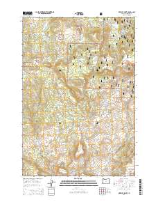
2014 Map of Wheeler Point
USGS Topo · Published 2014About this map
Umatilla National Forest dominates this section of Wheeler County, where the high-altitude terrain is marked by a series of meadows and clearings used for grazing and land management. Distinctive open areas like Widow Meadow, Dairy Meadow, and Chasteen Meadow punctuate the timbered ridges, while higher elevations are anchored by Frizzel Mtn and Indian Mtn. The hydrology of the area is defined by small, high-country water bodies including Hubbel Lake and Clark Lake, along with numerous seasonal drainages like Buckhorn Cr and Camp Cr. A network of Forest Service roads, such as Nat For Dev Rd 030, provides access to these isolated points. Cultural history is concentrated at the Winlock Cem near Winlock Ln, representing a physical connection to the early settlers and ranching families who navigated this complex landscape of ridges and basins including Snow Basin and Wineland Canyon.
Find a feature on this map
61 named features on this map. Tap any name to fly to it.
Don’t see what you’re looking for? This feature index may not catch every label — zoom into the map to look around manually.
Map Details
Editions of this 2014 Wheeler Point Map
This is the sole edition of this map. No revisions or reprints were ever made.
Other maps of this area

1916 · Condon
USGS Topo · 1:125,000

1926 · Mitchell
USGS Topo · 1:125,000

1953 · Spray
USGS Topo · 1:62,500

1953 · Pendleton
USGS Topo · 1:250,000

1953 · The Dalles
USGS Topo · 1:250,000

1955 · Bend
USGS Topo · 1:250,000

1955 · Canyon City
USGS Topo · 1:250,000

1956 · The Dalles
USGS Topo · 1:250,000

1956 · Pendleton
USGS Topo · 1:250,000

1957 · Bend
USGS Topo · 1:250,000