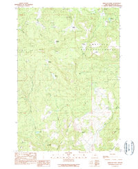
1990 Map of Wheeler Point
USGS Topo · Published 1990About this map
Umatilla National Forest encompasses the high-altitude terrain of the Wheeler and Grant county border, where the 1990 landscape is defined by remote mountain ridges and seasonal water sources. The former settlement of Wetmore (Site) near Wineland Lake and Wineland Canyon hints at earlier inhabitation, supported by a small Cem located near the eastern edge of the quadrangle. The topography is marked by a series of prominent meadows and basins, including Gutherie Prairie, Chasteen Meadow, and Snow Basin, which likely served as crucial grazing lands or landmarks for early travelers.
Find a feature on this map
36 named features on this map. Tap any name to fly to it.
Don’t see what you’re looking for? This feature index may not catch every label — zoom into the map to look around manually.
Map Details
Editions of this 1990 Wheeler Point Map
This is the sole edition of this map. No revisions or reprints were ever made.
Other maps of this area

1916 · Condon
USGS Topo · 1:125,000

1926 · Mitchell
USGS Topo · 1:125,000

1953 · Spray
USGS Topo · 1:62,500

1953 · Pendleton
USGS Topo · 1:250,000

1953 · The Dalles
USGS Topo · 1:250,000

1955 · Bend
USGS Topo · 1:250,000

1955 · Canyon City
USGS Topo · 1:250,000

1956 · The Dalles
USGS Topo · 1:250,000

1956 · Pendleton
USGS Topo · 1:250,000

1957 · Bend
USGS Topo · 1:250,000