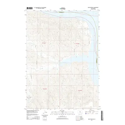
2015 Map of Whetstone Bay
USGS Topo · Published 2015About this map
The Missouri River defines the northern and eastern boundaries of this South Dakota landscape, where the waters of Lake Francis Case fill the valley floor. The terrain is deeply carved by a network of drainage systems, including Whetstone Cr and its northern branch, N Fork Whetstone Cr. The map reveals a rural infrastructure of township roads and section lines that navigate the high ground between these breaks. Local travel is facilitated by routes such as Mule Head Rd, Cabin Rd, and the Schriever Township Hwy in the southwest corner. The topography is marked by significant elevation changes where the plateau drops toward the river basin, with named tributaries like Burnt Rock Cr and Truesdell Cr cutting through the bluffs. This survey illustrates the modern intersection of water management and traditional township organization along the Gregory and Charles Mix county line.
Find a feature on this map
20 named features on this map. Tap any name to fly to it.
Don’t see what you’re looking for? This feature index may not catch every label — zoom into the map to look around manually.
Map Details
Editions of this 2015 Whetstone Bay Map
This is the sole edition of this map. No revisions or reprints were ever made.
Other maps of this area

1955 · Mitchell
USGS Topo · 1:250,000

1959 · Mitchell
USGS Topo · 1:250,000

1964 · Campbell Creek
USGS Topo · 1:24,000

1964 · Herrick NE
USGS Topo · 1:24,000

1964 · St. Charles
USGS Topo · 1:24,000

1964 · Whetstone Bay
USGS Topo · 1:24,000
1964 · South Scalp Creek
USGS Topo · 1:24,000
1964 · Bonesteel
USGS Topo · 1:24,000

1971 · Lucas SE
USGS Topo · 1:24,000

1979 · Castalia
USGS Topo · 1:24,000