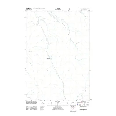
2011 Map of Whiskey Spring
USGS Topo · Published 2011About this map
West Fork Blacktail Deer Creek and its companion, the Middle Fork Blacktail Deer Creek, define the drainage patterns of this high-altitude landscape in Beaverhead County. The terrain is marked by distinct geological features, including the prominent Steamboat Rock and the elevations of Snowbank Ridge. Human presence is sparse and focused on ranching and seasonal access, anchored by the Cornell Ranch and the passage of Blacktail Rd. In the central portion of the map, the evocative names Moonshine Gulch and Whiskey Spring suggest the area's colorful local history. To the southwest, water resources are represented by Cooks Lake and the headwaters of Basin Creek, illustrating the remote nature of this southwestern Montana wilderness prior to modern development.
Find a feature on this map
13 named features on this map. Tap any name to fly to it.
Don’t see what you’re looking for? This feature index may not catch every label — zoom into the map to look around manually.
Map Details
Editions of this 2011 Whiskey Spring Map
This is the sole edition of this map. No revisions or reprints were ever made.
Other maps of this area

1955 · Dubois
USGS Topo · 1:250,000

1958 · Dubois
USGS Topo · 1:250,000
1968 · Price Creek
USGS Topo · 1:24,000

1968 · Whiskey Spring
USGS Topo · 1:24,000

1968 · Lima Dam
USGS Topo · 1:24,000
1968 · Price Creek NE
USGS Topo · 1:24,000

1968 · Vinegar Hill
USGS Topo · 1:24,000

1968 · Henry Gulch
USGS Topo · 1:24,000

1968 · Antone Peak
USGS Topo · 1:24,000
1968 · Swamp Creek
USGS Topo · 1:24,000