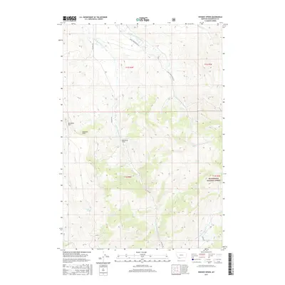
2017 Map of Whiskey Spring
USGS Topo · Published 2017About this map
Beaverhead National Forest encompasses much of this high-elevation landscape, where the headwaters of the Blacktail Deer Creek drainage begin their descent. The map highlights a complex network of seasonal drainages and mountain peaks, including the prominent Steamboat Rock and Snowbank Ridge. Water is a defining element of this terrain, from the secluded Cooks Lake to the eponymous Whiskey Spring, located just below Moonshine Gulch. The transport network is limited to remote access routes such as Blacktail Rd and Middle Fork Blacktail Rd, which follow the natural contours of the stream valleys. These features reflect the area's continued use for timber management, watershed protection, and high-country recreation within the Montana backcountry. The map also traces various creek branches, such as Basin Cr and Teddy Cr, which feed the larger W Fork Blacktail Deer Cr.
Find a feature on this map
20 named features on this map. Tap any name to fly to it.
Don’t see what you’re looking for? This feature index may not catch every label — zoom into the map to look around manually.
Map Details
Editions of this 2017 Whiskey Spring Map
This is the sole edition of this map. No revisions or reprints were ever made.
Other maps of this area

1955 · Dubois
USGS Topo · 1:250,000

1958 · Dubois
USGS Topo · 1:250,000
1968 · Price Creek
USGS Topo · 1:24,000

1968 · Whiskey Spring
USGS Topo · 1:24,000

1968 · Lima Dam
USGS Topo · 1:24,000
1968 · Price Creek NE
USGS Topo · 1:24,000

1968 · Vinegar Hill
USGS Topo · 1:24,000

1968 · Henry Gulch
USGS Topo · 1:24,000

1968 · Antone Peak
USGS Topo · 1:24,000
1968 · Swamp Creek
USGS Topo · 1:24,000