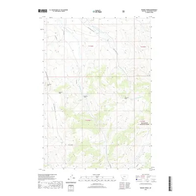
2020 Map of Whiskey Spring
USGS Topo · Published 2020About this map
Beaverhead National Forest covers much of this high-elevation landscape in Beaverhead County, where the topography is defined by the Snowcrest Range and Clover Divide. The drainage network is particularly dense here, with the Middle Fork Blacktail Deer Creek and West Fork Blacktail Deer Creek carving through the terrain. Named water sources such as Whiskey Spring and Cooks Lake provide vital landmarks in a region historically used for resource management and wilderness transit.
Find a feature on this map
24 named features on this map. Tap any name to fly to it.
Don’t see what you’re looking for? This feature index may not catch every label — zoom into the map to look around manually.
Map Details
Editions of this 2020 Whiskey Spring Map
This is the sole edition of this map. No revisions or reprints were ever made.
Other maps of this area

1955 · Dubois
USGS Topo · 1:250,000

1958 · Dubois
USGS Topo · 1:250,000
1968 · Price Creek
USGS Topo · 1:24,000

1968 · Whiskey Spring
USGS Topo · 1:24,000

1968 · Lima Dam
USGS Topo · 1:24,000
1968 · Price Creek NE
USGS Topo · 1:24,000

1968 · Vinegar Hill
USGS Topo · 1:24,000

1968 · Henry Gulch
USGS Topo · 1:24,000

1968 · Antone Peak
USGS Topo · 1:24,000
1968 · Swamp Creek
USGS Topo · 1:24,000