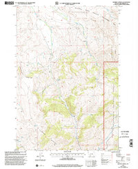
1997 Map of Whiskey Spring
USGS Topo · Published 2002About this map
The Blacktail State Wildlife Management Area and the Beaverhead National Forest converge in this high-altitude landscape of Beaverhead County. The map is defined by the hydrologic network of the West Fork Blacktail Deer Creek, Middle Fork Blacktail Deer Creek, and South Fork Blacktail Deer Creek, which carve deep drainages through the terrain. Human presence is concentrated at the Cornell Ranch and along the Cornell Trail, illustrating the intersection of private ranching and public land management in late-twentieth-century Montana.
Find a feature on this map
21 named features on this map. Tap any name to fly to it.
Don’t see what you’re looking for? This feature index may not catch every label — zoom into the map to look around manually.
Map Details
Editions of this 1997 Whiskey Spring Map
This is the sole edition of this map. No revisions or reprints were ever made.
Other maps of this area

1955 · Dubois
USGS Topo · 1:250,000

1958 · Dubois
USGS Topo · 1:250,000
1968 · Price Creek
USGS Topo · 1:24,000

1968 · Whiskey Spring
USGS Topo · 1:24,000

1968 · Lima Dam
USGS Topo · 1:24,000
1968 · Price Creek NE
USGS Topo · 1:24,000

1968 · Vinegar Hill
USGS Topo · 1:24,000

1968 · Henry Gulch
USGS Topo · 1:24,000

1968 · Antone Peak
USGS Topo · 1:24,000
1968 · Swamp Creek
USGS Topo · 1:24,000