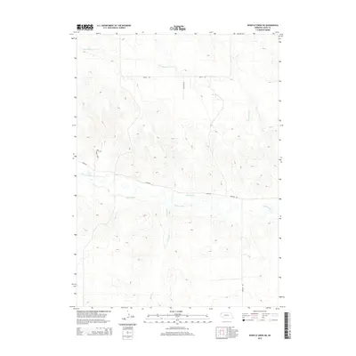
2014 Map of Whistle Creek NE
USGS Topo · Published 2014About this map
The Niobrara River winds through this northwestern Nebraska landscape, defining the character of a region where water management and ranching roads dominate the map. The elevation contours reveal the broken terrain of the High Plains, where the river valley is supported by early 21st-century irrigation infrastructure like Sandoz Ditch and Mentlen Ditch. While the area remains largely open rangeland, the presence of named corridors such as Pink School House Rd hints at the localized history of rural education and the distribution of pioneer school districts that once anchored these remote sections of Sioux County. Smaller watercourses like Whistle Cr and Barngrover Cr provide the primary drainage for the surrounding hills, while a network of established tracks including Hanley Rd and Corkscrew Rd connects the scattered homesteads of the Whistle Creek Precinct.
Find a feature on this map
10 named features on this map. Tap any name to fly to it.
Don’t see what you’re looking for? This feature index may not catch every label — zoom into the map to look around manually.
Map Details
Editions of this 2014 Whistle Creek NE Map
This is the sole edition of this map. No revisions or reprints were ever made.
Other maps of this area

1899 · Whistle Creek
USGS Topo · 1:125,000

1951 · Marsland
USGS Topo · 1:62,500

1955 · Alliance
USGS Topo · 1:250,000

1957 · Alliance
USGS Topo · 1:250,000

1958 · Alliance
USGS Topo · 1:250,000

1980 · Kyle Creek
USGS Topo · 1:24,000

1980 · Dead Mans Creek
USGS Topo · 1:24,000
1980 · Glen
USGS Topo · 1:24,000
1983 · Marsland SW
USGS Topo · 1:24,000
1983 · Marsland NW
USGS Topo · 1:24,000