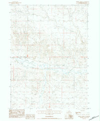
1983 Map of Whistle Creek NE
USGS Topo · Published 1984About this map
The Niobrara River winds through this section of the Nebraska panhandle, flanked by an intricate network of irrigation infrastructure essential to the high plains landscape. By the early 1980s, the valley featured the Mentlen Ditch, an Irr Canal, and a Flume, illustrating the managed water system required for agriculture in Sioux County. The terrain is defined by the confluence of Whistle Creek and Barngrover Creek, where the land rises into hills marked by a prominent Blow out to the northeast. Cultural landmarks of the era include the Pink Sch and a Gravel Pit, while a Levee stands along the riverbank as a measure of flood control. This map offers a clear look at the physical geography and ranching-related water management in a sparsely settled corner of the state.
Find a feature on this map
14 named features on this map. Tap any name to fly to it.
Don’t see what you’re looking for? This feature index may not catch every label — zoom into the map to look around manually.
Map Details
Editions of this 1983 Whistle Creek NE Map
This is the sole edition of this map. No revisions or reprints were ever made.
Other maps of this area

1899 · Whistle Creek
USGS Topo · 1:125,000

1951 · Marsland
USGS Topo · 1:62,500

1955 · Alliance
USGS Topo · 1:250,000

1957 · Alliance
USGS Topo · 1:250,000

1958 · Alliance
USGS Topo · 1:250,000

1980 · Kyle Creek
USGS Topo · 1:24,000

1980 · Dead Mans Creek
USGS Topo · 1:24,000
1980 · Glen
USGS Topo · 1:24,000
1983 · Marsland SW
USGS Topo · 1:24,000
1983 · Marsland NW
USGS Topo · 1:24,000