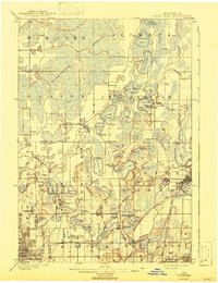
1902 Map of White Bear
USGS Topo · Published 1943About this map
White Bear Lake and its surrounding wetlands define this turn-of-the-century landscape north of the Twin Cities. The area is characterized by an extensive network of lakes and marshes, most notably the Wiregrass Marsh which dominates the northern townships of Ham Lake and Blaine. This environment necessitated early hydraulic engineering, evident in the network of Ditch and Canal segments that drain the land. To the south, the emergence of New Brighton as a regional hub is marked by the presence of the Minneapolis Stock Yards and the convergence of several rail lines, including the St. Paul & Duluth R.R. and the Northern Pacific R.R.. Infrastructure for the growing metropolitan area is well-established, with the Minneapolis Reservoir and various Pumping Stations and Artesian Wells strategically placed to harness the region's abundant water resources.
Find a feature on this map
83 named features on this map. Tap any name to fly to it.
Don’t see what you’re looking for? This feature index may not catch every label — zoom into the map to look around manually.
Map Details
Editions of this 1902 White Bear Map
4 editions found
Other maps of this area

1896 · Minneapolis
USGS Topo · 1:62,500

1896 · St. Paul
USGS Topo · 1:62,500

1901 · Minneapolis
USGS Topo · 1:62,500

1902 · White Bear
USGS Topo · 1:62,500

1902 · Anoka
USGS Topo · 1:62,500

1916 · St. Francis
USGS Topo · 1:62,500

1919 · St. Francis
USGS Topo · 1:62,500

1946 · Hudson
USGS Topo · 1:62,500

1948 · Stillwater
USGS Topo · 1:62,500

1949 · Hudson
USGS Topo · 1:62,500