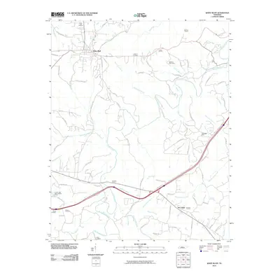
2010 Map of White Bluff
USGS Topo · Published 2010About this map
White Bluff and the settlement of New Hope anchor this landscape, where the headwaters of numerous creeks carve through the central Tennessee terrain. The area is defined by a dense network of watercourses, including the winding Turnbull Creek and Big Turnbull Creek, which eventually meet the Harpeth River in the northeast. This 2010 survey reveals a community deeply connected to its local history through numerous family and community burial grounds, such as Pinkerton Cemetery, Carothers Cemetery, and Hutton Cemetery.
Find a feature on this map
91 named features on this map. Tap any name to fly to it.
Don’t see what you’re looking for? This feature index may not catch every label — zoom into the map to look around manually.
Map Details
Editions of this 2010 White Bluff Map
This is the sole edition of this map. No revisions or reprints were ever made.
Other maps of this area

1901 · Colombia
USGS Topo · 1:125,000

1930 · White Bluff
USGS Topo · 1:62,500

1933 · White Bluff
USGS Topo · 1:62,500

1936 · Burns
USGS Topo · 1:24,000

1936 · Craigfield
USGS Topo · 1:24,000

1936 · Lyles
USGS Topo · 1:24,000

1951 · Fairview
USGS Topo · 1:24,000
1953 · Lyles
USGS Topo · 1:24,000
1953 · Craigfield
USGS Topo · 1:24,000

1953 · Burns
USGS Topo · 1:24,000