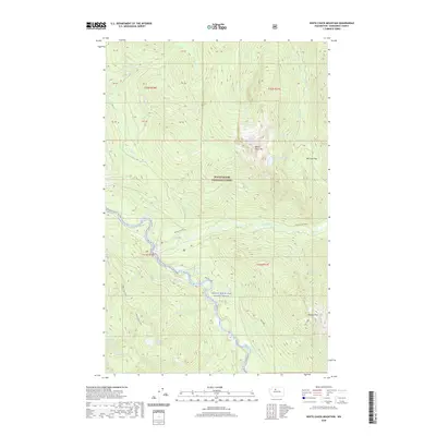
2020 Map of White Chuck Mountain
USGS Topo · Published 2020About this map
Mount Baker National Forest preserves a landscape of high alpine passes and complex river drainages in this 2020 survey of Snohomish County. The White Chuck River and its designated Skagit Wild and Scenic River corridor define the valley floors, providing a striking contrast to the surrounding elevations of White Chuck Mountain. Distinctive landforms like the Whitechuck Bench sit above the river, while multiple high-elevation water bodies including Peek-A-Boo Lake, Goodman Lake, and Thornton Lake are nestled among the peaks. For those tracing historical transit through the Cascades, the map clearly identifies established routes such as Rat Trap Pass and Stujack Pass, which connect the deep drainages of Straight Cr and Stujack Cr.
Find a feature on this map
39 named features on this map. Tap any name to fly to it.
Don’t see what you’re looking for? This feature index may not catch every label — zoom into the map to look around manually.
Map Details
Editions of this 2020 White Chuck Mountain Map
This is the sole edition of this map. No revisions or reprints were ever made.
Other maps of this area

1899 · Glacier Peak
USGS Topo · 1:125,000

1899 · Stillaguamish
USGS Topo · 1:125,000

1901 · Glacier Peak
USGS Topo · 1:125,000

1901 · Stilaguamish
USGS Topo · 1:125,000

1955 · Concrete
USGS Topo · 1:250,000

1957 · Silverton
USGS Topo · 1:62,500

1958 · Concrete
USGS Topo · 1:250,000

1962 · Concrete
USGS Topo · 1:250,000
1966 · Huckleberry Mtn
USGS Topo · 1:24,000
1966 · Sloan Peak
USGS Topo · 1:24,000