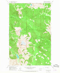
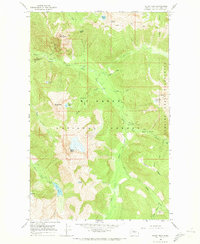
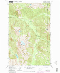
1966 Map of Sloan Peak
USGS Topo · Published 1968About this map
Mount Baker National Forest dominates this high-altitude landscape, where the Glacier Peak Wilderness boundary defines the eastern edge of the survey. The terrain is marked by sharp topographic relief, centered on the towering summit of Sloan Peak and the nearby Bedal Peak. Drainage patterns are defined by the North Fork Sauk River and Sloan Creek, which collect waters from numerous alpine basins such as those holding Goat Lake and Cadet Lake.
Find a feature on this map
37 named features on this map. Tap any name to fly to it.
Don’t see what you’re looking for? This feature index may not catch every label — zoom into the map to look around manually.
Map Details
Editions of this 1966 Sloan Peak Map
4 editions found
Historical Maps of Snohomish County Through Time
68 maps found

1899 Glacier Peak
Snohomish County, WA

1899 Stillaguamish
Snohomish County, WA

1901 Glacier Peak
Snohomish County, WA

1901 Stillaguamish
Snohomish County, WA

1911 Mt Vernon
Snohomish County, WA

1950 Glacier Peak
Snohomish County, WA

1953 Edmonds East
Snohomish County, WA

1953 Edmonds West
Snohomish County, WA

1956 Arlington East
Snohomish County, WA

1956 Arlington West
Snohomish County, WA

1956 Tulalip
Snohomish County, WA

1957 Silverton
Snohomish County, WA

1965 Bench Mark Mtn
Snohomish County, WA

1965 Blanca Lake
Snohomish County, WA

1965 Captain Point
Snohomish County, WA

1965 Evergreen Mtn
Snohomish County, WA

1965 Monte Cristo
Snohomish County, WA

1966 Bedal
Snohomish County, WA

1966 Pugh Mountain
Snohomish County, WA

1966 Sloan Peak
Snohomish County, WA

1966 White Chuck Mtn.
Snohomish County, WA

1988 Gamma Peak
Snohomish County, WA

1988 Glacier Peak East
Snohomish County, WA

1988 Glacier Peak West
Snohomish County, WA

1988 Lime Mountain
Snohomish County, WA

1989 Helena Ridge
Snohomish County, WA

1989 Lake Chaplain
Snohomish County, WA

1989 Mallardy Ridge
Snohomish County, WA

1989 Meadow Mountain
Snohomish County, WA

1989 Mount Stickney
Snohomish County, WA

1989 Riley Lake
Snohomish County, WA

1989 Silverton
Snohomish County, WA

1989 Wallace Lake
Snohomish County, WA

1989 Whitehorse Mtn.
Snohomish County, WA

1997 Edmonds West
Snohomish County, WA

1999 Gamma Peak
Snohomish County, WA

1999 Glacier Peak East
Snohomish County, WA

1999 Glacier Peak West
Snohomish County, WA

1999 Lime Mountain
Snohomish County, WA

1999 Mount Pugh
Snohomish County, WA

1999 Sloan Peak
Snohomish County, WA

2023 Arlington East
Snohomish County, WA

2023 Arlington West
Snohomish County, WA

2023 Bedal
Snohomish County, WA

2023 Benchmark Mountain
Snohomish County, WA

2023 Blanca Lake
Snohomish County, WA

2023 Captain Point
Snohomish County, WA

2023 Edmonds East
Snohomish County, WA

2023 Edmonds West
Snohomish County, WA

2023 Evergreen Mountain
Snohomish County, WA

2023 Gamma Peak
Snohomish County, WA

2023 Glacier Peak East
Snohomish County, WA

2023 Glacier Peak West
Snohomish County, WA

2023 Helena Ridge
Snohomish County, WA

2023 Lake Chaplain
Snohomish County, WA

2023 Lime Mountain
Snohomish County, WA

2023 Mallardy Ridge
Snohomish County, WA

2023 Meadow Mountain
Snohomish County, WA

2023 Monte Cristo
Snohomish County, WA

2023 Mount Pugh
Snohomish County, WA

2023 Mount Stickney
Snohomish County, WA

2023 Riley Lake
Snohomish County, WA

2023 Silverton
Snohomish County, WA

2023 Sloan Peak
Snohomish County, WA

2023 Tulalip
Snohomish County, WA

2023 Wallace Lake
Snohomish County, WA

2023 White Chuck Mountain
Snohomish County, WA

2023 Whitehorse Mountain
Snohomish County, WA