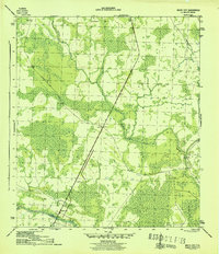
1945 Map of White City
USGS Topo · Published 1945About this map
White City serves as the primary hub of this Gulf County landscape, situated along the strategic Intracoastal Waterway. The environment in the mid-1940s is defined by a blend of maritime transit and timber industry infrastructure, with a Logging RR and the Old Millville Road cutting through the lowlands. The presence of the St Joe Fire Tower highlights the era's focus on forest management and vigilance over the surrounding pine and cypress stands. North of the settlement, Cypress Creek meanders through the wetlands, illustrating the natural drainage patterns that shaped local development. This map provides a clear record of the intersection between industrial transport and the coastal geography of the Florida panhandle just as the post-war era began.
Find a feature on this map
7 named features on this map. Tap any name to fly to it.
Don’t see what you’re looking for? This feature index may not catch every label — zoom into the map to look around manually.
Map Details
Editions of this 1945 White City Map
3 editions found
Other maps of this area

1943 · Port St. Joe
USGS Topo · 1:31,680

1943 · Overstreet
USGS Topo · 1:31,680

1943 · Jackson River
USGS Topo · 1:24,000

1944 · White City
USGS Topo · 1:24,000

1944 · Forbes Island
USGS Topo · 1:24,000

1945 · Forbes Island
USGS Topo · 1:31,680

1945 · Lake Wimico
USGS Topo · 1:31,680

1945 · Kennedy Creek
USGS Topo · 1:31,680

1945 · White City
USGS Topo · 1:31,680

1945 · Wewahitchka
USGS Topo · 1:31,680