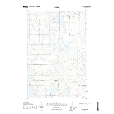
2019 Map of White Fish Lake
USGS Topo · Published 2019About this map
White Fish Lake and Three Island Lake anchor this glaciated landscape in northern Minnesota, where a dense network of water bodies and wetlands dominates the terrain. The map reveals a complex hydrographic system including Pollivog Lake, Silver Lake, and Gull Lake, connected by smaller waterways like Darrigans Creek and O'Brien Cr. The road network, featuring names such as Knappen Hill Rd NE and Buena Vista Forest Rd 10, suggests a region deeply integrated with forest management and seasonal recreation. While large settlements are absent, the clustering of residential roads around the shorelines of Jackson Lake and Bass Lake indicates a pattern of lakeside development typical of the state's lake country. Significant portions of the southern half are designated within the t148n r33w and t148n r32w townships, highlighting the sectioned nature of this forested wilderness.
Find a feature on this map
56 named features on this map. Tap any name to fly to it.
Don’t see what you’re looking for? This feature index may not catch every label — zoom into the map to look around manually.
Map Details
Editions of this 2019 White Fish Lake Map
This is the sole edition of this map. No revisions or reprints were ever made.
Other maps of this area

1919 · Quiring
USGS Topo · 1:62,500

1920 · Buena Vista
USGS Topo · 1:62,500

1954 · Bemidji
USGS Topo · 1:250,000

1957 · Bemidji
USGS Topo · 1:250,000

1958 · Bemidji
USGS Topo · 1:250,000

1972 · Peterson Lake
USGS Topo · 1:24,000

1972 · Turtle River Lake
USGS Topo · 1:24,000

1972 · Redby
USGS Topo · 1:24,000

1972 · White Fish Lake
USGS Topo · 1:24,000
1972 · O'Brien Lookout Tower
USGS Topo · 1:24,000