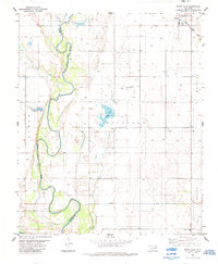
1984 Map of White Lake
USGS Topo · Published 1985About this map
Tipton anchors the northeast corner of this southwestern Oklahoma landscape, where the Missouri - Kansas - Texas railroad line cuts through the prairie toward the town's edge. The geography is dominated by the meandering course of the North Fork Red River, which forms a persistent boundary between Jackson and Tillman Counties. This riparian corridor is marked by complex sandbars and seasonal shifts, evidenced by the large Spillway structure and the namesake White Lake situated in the central Richland township area.
Find a feature on this map
14 named features on this map. Tap any name to fly to it.
Don’t see what you’re looking for? This feature index may not catch every label — zoom into the map to look around manually.
Map Details
Editions of this 1984 White Lake Map
This is the sole edition of this map. No revisions or reprints were ever made.
Other maps of this area

1955 · Lawton
USGS Topo · 1:250,000

1958 · Frederick
USGS Topo · 1:62,500

1958 · Elmer
USGS Topo · 1:62,500

1963 · Altus SE
USGS Topo · 1:24,000

1964 · Tipton SE
USGS Topo · 1:24,000

1964 · Tipton
USGS Topo · 1:24,000

1975 · Elmore City NE
USGS Topo · 1:24,000

1975 · Frederick NE
USGS Topo · 1:24,000

1975 · Frederick SW
USGS Topo · 1:24,000

1975 · Frederick NW
USGS Topo · 1:24,000