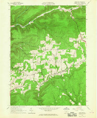
1965 Map of White Pine
USGS Topo · Published 1967About this map
Cogan House serves as a central hub for this Lycoming County landscape, where small upland clearings for agriculture meet the dense woods of the State Game Lands No 75. The map reveals the settlement patterns of the mid-1960s, documenting local landmarks like the Cogan House Sch and the Persun Cem south of Beech Grove. This area is defined by its complex drainage network, where Blockhouse Creek and Larrys Creek carve through the terrain, separated by prominent ridges such as Buckhorn Mountain. To the north, Jackson Corners and Buttonwood sit near the headwaters of Wolf Run, while specialized sites like Fishermans Point and Club House Point suggest the long-standing importance of outdoor recreation and hunting in the north-central Pennsylvania highlands.
Find a feature on this map
49 named features on this map. Tap any name to fly to it.
Don’t see what you’re looking for? This feature index may not catch every label — zoom into the map to look around manually.
Map Details
Editions of this 1965 White Pine Map
3 editions found
Other maps of this area

1921 · Trout Run
USGS Topo · 1:62,500

1923 · Trout Run
USGS Topo · 1:62,500

1925 · Blossburg
USGS Topo · 1:62,500

1927 · Blossburg
USGS Topo · 1:62,500

1935 · Waterville
USGS Topo · 1:24,000

1937 · Waterville
USGS Topo · 1:48,000

1943 · Waterville
USGS Topo · 1:62,500

1944 · Blossburg
USGS Topo · 1:62,500

1944 · Trout Run
USGS Topo · 1:62,500

1946 · Antrim
USGS Topo · 1:62,500
Featured Places
- Steam Valley, Cogan House Township
- White Pine, Cogan House Township
- Cogan House Township, PA
- Pine Township, PA
- Jackson Township, PA