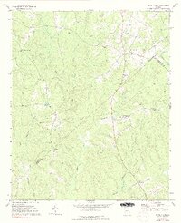
1972 Map of White Plains
USGS Topo · Published 1991About this map
White Plains serves as the primary settlement in this section of rural Georgia, situated where the ridge-top roads meet the drainages of Bruce Creek and Johnson Creek. The landscape is defined by its numerous small-scale religious and community landmarks, such as Pierce Chapel and Mt Stephens Ch, which anchor the local geography. A complex network of creeks, including Little Shoulderbone Creek and Lundy Creek, dissects the terrain, while the boundary between Greene County and Hancock County cuts through the southwestern corner near Centennial Ch. The presence of several community anchors like County Line Ch and County Line Cem highlights a pattern of settlement where local life centered around these rural intersections and family burial grounds. Further north, Mosquito Crossing stands as a notable crossroads, while the broader topography is shaped by features like Copeland Hill and the seasonal flows of Whitten Creek and Plunkett Creek.
Find a feature on this map
26 named features on this map. Tap any name to fly to it.
Don’t see what you’re looking for? This feature index may not catch every label — zoom into the map to look around manually.
Map Details
Editions of this 1972 White Plains Map
2 editions found
Other maps of this area

1906 · Crawfordville
USGS Topo · 1:125,000

1953 · Athens
USGS Topo · 1:250,000

1958 · Athens
USGS Topo · 1:250,000

1959 · Athens
USGS Topo · 1:250,000

1963 · Athens
USGS Topo · 1:250,000

1965 · Union Point
USGS Topo · 1:24,000

1966 · Crawfordville
USGS Topo · 1:24,000

1972 · Liberty
USGS Topo · 1:24,000

1972 · Shoulderbone
USGS Topo · 1:24,000

1972 · Sparta NW
USGS Topo · 1:24,000