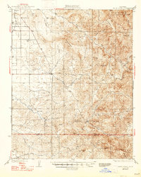
1936 Map of White River
USGS Topo · Published 1947About this map
The Tule River Indian Reservation anchors the northeastern highlands of this Tulare County landscape, where the terrain shifts from the flat San Joaquin Valley floor into the rising Sierra Nevada foothills. Surveyed between 1926 and 1932, the map documents a transition from agricultural settlements like Deer Creek Colony and Ultra in the west to the more isolated mining and ranching outposts of the interior. The historic community of White River sits at the confluence of several drainages, serving as a focal point near the La Grange Mine and Bald Mtn. Local infrastructure is defined by early schools such as Grandview Sch and Quincy Sch, alongside a prominent Transmission Line that cuts across Huey Valley and Tennessee Ridge. The presence of Telegraph Flat and Fountain Springs suggests the importance of water and communication routes in this rural landscape before mid-century development.
Find a feature on this map
35 named features on this map. Tap any name to fly to it.
Don’t see what you’re looking for? This feature index may not catch every label — zoom into the map to look around manually.
Map Details
Editions of this 1936 White River Map
3 editions found

Other maps of this area

1904 · Kaweah
USGS Topo · 1:125,000

1909 · Kaweah
USGS Topo · 1:125,000

1920 · Delonagha
USGS Topo · 1:62,500

1926 · Quincy School
USGS Topo · 1:31,680

1926 · Glennville
USGS Topo · 1:62,500

1929 · Richgrove
USGS Topo · 1:31,680

1929 · Porterville
USGS Topo · 1:31,680

1929 · Quincy School
USGS Topo · 1:31,680

1929 · Ducor
USGS Topo · 1:31,680

1931 · Deepwell Ranch
USGS Topo · 1:31,680