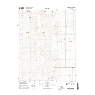
2014 Map of White Rock Peak
USGS Topo · Published 2014About this map
White Rock Peak serves as a prominent landmark along the jagged boundary between Nevada and Utah, anchoring a landscape defined by isolated water sources and high-elevation terrain. This 2014 survey reveals a network of vital desert springs, such as White Rock Cabin Springs, South Camp Spring, and Log Cabin Spring, which historically supported ranching and transit through this arid corridor. The topography transitions from the high White Rock Mountains down into the wide expanse of Hamlin Valley to the northeast. Transportation is limited to rugged tracks like Reed Cabin Rd and Spring Valley Rd, which cross the state line near Reeds Cabin Summit. This map illustrates the intersection of Lincoln and Beaver Counties, highlighting a remote region where survival and movement depended entirely on the precise locations of features like Devil Rock Springs and Ticapoo Spring.
Find a feature on this map
43 named features on this map. Tap any name to fly to it.
Don’t see what you’re looking for? This feature index may not catch every label — zoom into the map to look around manually.
Map Details
Editions of this 2014 White Rock Peak Map
This is the sole edition of this map. No revisions or reprints were ever made.
Other maps of this area

1953 · Richfield
USGS Topo · 1:250,000

1956 · Lund
USGS Topo · 1:250,000

1958 · Richfield
USGS Topo · 1:250,000

1960 · Lund
USGS Topo · 1:250,000

1971 · Steamboat Mtn SW
USGS Topo · 1:24,000

1971 · Atchison Creek
USGS Topo · 1:24,000

1972 · Gleason Basin
USGS Topo · 1:24,000

1972 · White Rock Peak
USGS Topo · 1:24,000
1972 · Rice Mountain
USGS Topo · 1:24,000

1972 · Buck Wash Well
USGS Topo · 1:24,000