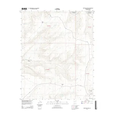
2014 Map of White Rock Wash
USGS Topo · Published 2014About this map
Canyon De Chelly National Monument stretches across the northern boundary of this high-desert landscape, where the plateau drops away into deep drainage systems. The hydrography of the region is defined by the Nazlini Creek and its namesake Nazlini Canyon to the west, while the eastern portion is dominated by the Defiance Plateau and the prominent landmark of Fluted Rock. A network of Bureau of Indian Affairs routes, including Bia-7 and Bia-26, provides the primary transit through these rugged townships. Several remote water sources, such as Honeymoon Spring, Tsegito Spring, and White Rock Spring, suggest the critical importance of reliable water in this arid environment. The map records the complex terrain of Upper Forest Mtn and the winding course of White Rock Wash, illustrating the natural barriers and conduits that shaped movement through this part of the Chinle Agency.
Find a feature on this map
22 named features on this map. Tap any name to fly to it.
Don’t see what you’re looking for? This feature index may not catch every label — zoom into the map to look around manually.
Map Details
Editions of this 2014 White Rock Wash Map
This is the sole edition of this map. No revisions or reprints were ever made.
Other maps of this area

1886 · Fort Defiance
USGS Topo · 1:250,000

1892 · Fort Defiance
USGS Topo · 1:250,000

1892 · Canyon De Chelly
USGS Topo · 1:250,000

1954 · Shiprock
USGS Topo · 1:250,000

1954 · Gallup
USGS Topo · 1:250,000

1955 · Zith-Tusayan Butte 2 SE
USGS Topo · 1:24,000

1955 · Zith-Tusayan Butte 2 SW
USGS Topo · 1:24,000

1955 · Zith-Tusayan Butte 2 NW
USGS Topo · 1:24,000

1955 · Zith-Tusayan Butte 2 NE
USGS Topo · 1:24,000

1955 · Sonsala Butte 3 SE
USGS Topo · 1:24,000