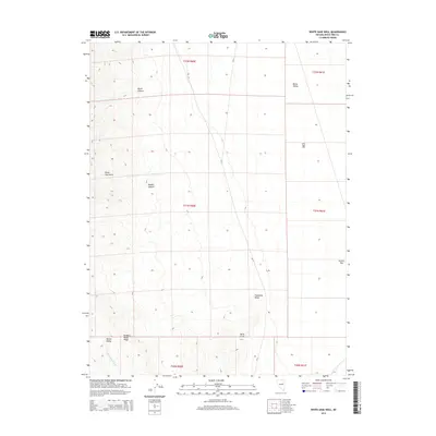
2014 Map of White Sage Well
USGS Topo · Published 2014About this map
Butte Valley dominates this high-desert landscape in White Pine County, where water and survival are marked by isolated improvements and family-named landmarks. The map documents a network of vital water sources, including the eponymous White Sage Well, McBrides Sheep Well, and Franks Well. These sites, along with Cow Camp and Cabin Spring, illustrate the enduring cattle and sheep ranching traditions of this Great Basin region. The topography is defined by the Butte Mountains to the west, cut by North Canyon and Middle Canyon, while Robbers Roost Ridge stands out in the south near Queue Valley. This 2014 survey records a remote terrain where the historical patterns of land use are anchored by named locations like Thirtymile Ranch and Dickenson Well, connected primarily by the north-south route of CR-17.
Find a feature on this map
24 named features on this map. Tap any name to fly to it.
Don’t see what you’re looking for? This feature index may not catch every label — zoom into the map to look around manually.
Map Details
Editions of this 2014 White Sage Well Map
This is the sole edition of this map. No revisions or reprints were ever made.
Other maps of this area

1956 · Ely
USGS Topo · 1:250,000

1959 · Ely
USGS Topo · 1:250,000
1962 · Hunter Point
USGS Topo · 1:24,000

1963 · Ely
USGS Topo · 1:250,000
1982 · Cabin Spring
USGS Topo · 1:24,000

1982 · White Sage Well
USGS Topo · 1:24,000
1982 · McBrides Sheep Well
USGS Topo · 1:24,000
1982 · Cow Camp
USGS Topo · 1:24,000
1982 · Franks Well
USGS Topo · 1:24,000

1982 · Dickenson Well
USGS Topo · 1:24,000