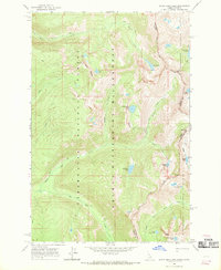
1966 Map of White Sand Lake
USGS Topo · Published 1969About this map
The Selway-Bitterroot Wilderness and adjacent national forests are depicted here during the mid-1960s, capturing a high-elevation backcountry area spanning the Idaho Montana state line. The landscape is defined by its extensive system of Pack Trails, which provided the primary means of access through these protected lands. A Lookout Tower situated on Dan Ridge offers a vertical perspective over the drainage of Maud Creek and Dodge Lake.
Find a feature on this map
33 named features on this map. Tap any name to fly to it.
Don’t see what you’re looking for? This feature index may not catch every label — zoom into the map to look around manually.
Map Details
Editions of this 1966 White Sand Lake Map
2 editions found
Other maps of this area

1901 · Hamilton
USGS Topo · 1:125,000

1911 · Lolo
USGS Topo · 1:250,000

1912 · Missoula
USGS Topo · 1:125,000

1913 · Lolo
USGS Topo · 1:250,000

1956 · Hamilton
USGS Topo · 1:250,000

1959 · Hamilton
USGS Topo · 1:250,000

1960 · Hamilton
USGS Topo · 1:250,000

1964 · Hamilton
USGS Topo · 1:250,000

1964 · Roundtop
USGS Topo · 1:24,000

1964 · St. Joseph Peak
USGS Topo · 1:24,000