
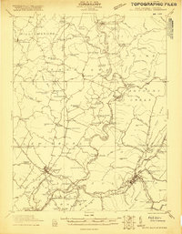
1921 Map of White Sulphur Springs
USGS Topo · Published 1921About this map
The Greenbrier River carves a deep, winding path through this 1921 survey, serving as the central geographic feature for the surrounding communities in Greenbrier County. The landscape is defined by the heavy presence of local education and faith, evidenced by an exceptionally high density of rural schoolhouses and churches such as Germany School, Gilboa School, and Walnut Grove Church. These small structures, many likely consisting of a single room, indicate a decentralized and community-focused settlement pattern typical of the era before the consolidation of public school districts.
Find a feature on this map
60 named features on this map. Tap any name to fly to it.
Don’t see what you’re looking for? This feature index may not catch every label — zoom into the map to look around manually.
Map Details
Editions of this 1921 White Sulphur Springs Map
2 editions found
Other maps of this area

1887 · Hinton
USGS Topo · 1:125,000

1887 · Lewisburg
USGS Topo · 1:125,000

1889 · Nicholas
USGS Topo · 1:125,000

1891 · Lewisburg
USGS Topo · 1:125,000

1891 · Nicholas
USGS Topo · 1:125,000

1891 · Huntersville
USGS Topo · 1:125,000

1892 · Hinton
USGS Topo · 1:125,000

1894 · Huntersville
USGS Topo · 1:125,000

1901 · Nicholas
USGS Topo · 1:125,000

1918 · Richwood
USGS Topo · 1:62,500