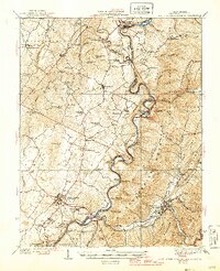
1939 Map of White Sulphur Springs
USGS Topo · Published 1946About this map
The Greenbrier River meanders through this portion of West Virginia, serving as the primary corridor for the Chesapeake and Ohio railroad. In the 1930s, the landscape was defined by an extensive network of small rural schools, including the Germany School, Rapp School, and Chestnut Flat School, reflecting a period of localized education before district consolidation. The county seat at Lewisburg sits as a crossroads west of the river, while the resort area of White Sulphur Springs is anchored in the southeast near Kates Mountain. This survey documents a transition from the rugged slopes of the Monongahela National Forest to the productive valley lands around Frankford and Maxwelton. Local landmarks like Falling Spring and the Renick PO and Sta illustrate the essential connection between natural springs, rail infrastructure, and early settlement patterns.
Find a feature on this map
98 named features on this map. Tap any name to fly to it.
Don’t see what you’re looking for? This feature index may not catch every label — zoom into the map to look around manually.
Map Details
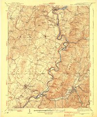
Editions of this 1939 White Sulphur Springs Map
2 editions found
Other maps of this area

1887 · Hinton
USGS Topo · 1:125,000

1887 · Lewisburg
USGS Topo · 1:125,000

1889 · Nicholas
USGS Topo · 1:125,000

1891 · Lewisburg
USGS Topo · 1:125,000

1891 · Nicholas
USGS Topo · 1:125,000

1891 · Huntersville
USGS Topo · 1:125,000

1892 · Hinton
USGS Topo · 1:125,000

1894 · Huntersville
USGS Topo · 1:125,000

1901 · Nicholas
USGS Topo · 1:125,000
1918 · Richwood
USGS Topo · 1:62,500