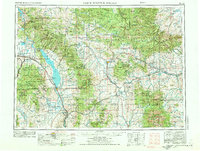
1958 Map of White Sulphur Springs
USGS Topo · Published 1974About this map
Canyon Ferry Lake dominates the central landscape of this West-Central Montana survey, where the Missouri River corridor serves as a hub for both industry and agriculture. The map illustrates a complex network of transportation and power generation during the mid-20th century, including the Canyon Ferry Dam and the Hauser Dam Power plant. Settlement patterns are defined by the convergence of the Burlington Northern and the Chicago Milwaukee St Paul and Pacific railroads, which connected mountain mining districts to valley towns. Local history is recorded in sites like the Iron Mountain Mine and Golden Age Mine, while small communities like Radersburg and Wilsall highlight the rural ranching economy. The vast reach of the Helena National Forest and Lewis and Clark National Forest frames the populated corridors, tracing the transition from the high peaks of Crazy Peak to the irrigated fields along Mullins Ditch.
Find a feature on this map
51 named features on this map. Tap any name to fly to it.
Don’t see what you’re looking for? This feature index may not catch every label — zoom into the map to look around manually.
Map Details
Editions of this 1958 White Sulphur Springs Map
3 editions found

Other maps of this area

1886 · Great Falls
USGS Topo · 1:250,000

1886 · Fort Logan
USGS Topo · 1:250,000

1886 · Little Belt Mts.
USGS Topo · 1:250,000

1888 · Three Forks
USGS Topo · 1:250,000

1889 · Big Snowy Mountain
USGS Topo · 1:250,000

1889 · Helena
USGS Topo · 1:250,000

1890 · Fort Benton
USGS Topo · 1:250,000

1891 · Livingston
USGS Topo · 1:250,000

1891 · Big Timber
USGS Topo · 1:125,000

1892 · Fort Benton
USGS Topo · 1:250,000