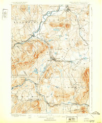
1900 Map of Whitefield
USGS Topo · Published 1932About this map
Whitefield and Lancaster anchor this late 19th-century landscape where the industrial and recreational character of the White Mountains is on full display. The convergence of major rail lines, including the Maine Central R. R. and the Boston and Maine R. R., created a complex network of hubs like Whitefield Junction and Quebec Junction. This infrastructure supported both the timber industry and the burgeoning tourism era, evidenced by the prominent locations of the Mount View House and Overlook House. To the west, the Connecticut River marks the state boundary, though the margin notes the state line remained in controversy during the survey. The southern portion of the map transition into high peaks and the White Mountain National Forest, where the terrain rises toward Three Sugarloaves and Agassiz Mt.. The settlement pattern follows the river valleys and rail corridors, connecting established towns like Bethlehem and Maplewood to the more remote eastern reaches of the White Mountains.
Find a feature on this map
89 named features on this map. Tap any name to fly to it.
Don’t see what you’re looking for? This feature index may not catch every label — zoom into the map to look around manually.
Map Details
Editions of this 1900 Whitefield Map
5 editions found
Other maps of this area

1893 · Mt. Washington
USGS Topo · 1:62,500

1895 · Crawford Notch
USGS Topo · 1:62,500

1896 · Mt. Washington
USGS Topo · 1:62,500

1896 · Crawford Notch
USGS Topo · 1:62,500

1900 · Whitefield
USGS Topo · 1:62,500

1920 · Guildhall
USGS Topo · 1:62,500

1929 · Moosilauke
USGS Topo · 1:62,500

1929 · Franconia
USGS Topo · 1:62,500

1930 · Percy
USGS Topo · 1:62,500

1931 · Guildhall
USGS Topo · 1:48,000