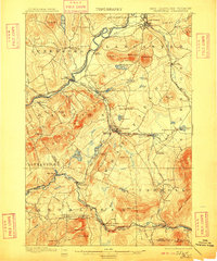
1900 Map of Whitefield
USGS Topo · Published 1909About this map
The Connecticut River forms a critical corridor through this New Hampshire terrain, serving as the border between Lancaster and Vermont's Lunenburg during the late nineteenth century. This era was defined by a complex network of rail infrastructure, where the Maine Central R. R. and the Boston and Maine R. R. intersected at numerous specialized transfer points. These hubs, such as Whitefield Junction and Waumbek Junction, facilitated the movement of goods and timber from the White Mountains and the Johns River valley.
Find a feature on this map
88 named features on this map. Tap any name to fly to it.
Don’t see what you’re looking for? This feature index may not catch every label — zoom into the map to look around manually.
Map Details
Editions of this 1900 Whitefield Map
5 editions found
Other maps of this area

1893 · Mt. Washington
USGS Topo · 1:62,500

1895 · Crawford Notch
USGS Topo · 1:62,500

1896 · Mt. Washington
USGS Topo · 1:62,500

1896 · Crawford Notch
USGS Topo · 1:62,500

1900 · Whitefield
USGS Topo · 1:62,500

1920 · Guildhall
USGS Topo · 1:62,500

1929 · Moosilauke
USGS Topo · 1:62,500

1929 · Franconia
USGS Topo · 1:62,500

1930 · Percy
USGS Topo · 1:62,500

1931 · Guildhall
USGS Topo · 1:48,000